Sunday, March 20, 2016

Hike Between Grange Hall Rd and Leonard Lee Road along the Little Manatee River, 3-19-16

Started about 8:30am at Grange Hall Road just south of the Little Manatee River and headed west to Leonard Lee Road.  Had to park on the shoulder of Grange Hall Road.  There was no where else to park.  It was already starting to get warm, the sun was shining but the grass and plants were still wet with dew.

Once I got to Leonard Lee Road, I had to turn around and followed the same route back to Grange Hall Road where my vehicle was parked.

The trail went roughly parallel to the Little Manatee River on the south side of the river.  It never got close enough to the river to see the river. 

Went through a mixture of woods and old fields that are filled with palmettos now, with some trees starting to take hold.  The wooded areas were for the most part old live oaks.

 Close to the beginning had to wade through a low spot filled with water.  It was about one foot deep.  Had wet feet the rest of the walk.


This is what the trail looked like part of the way.  There was much variation.

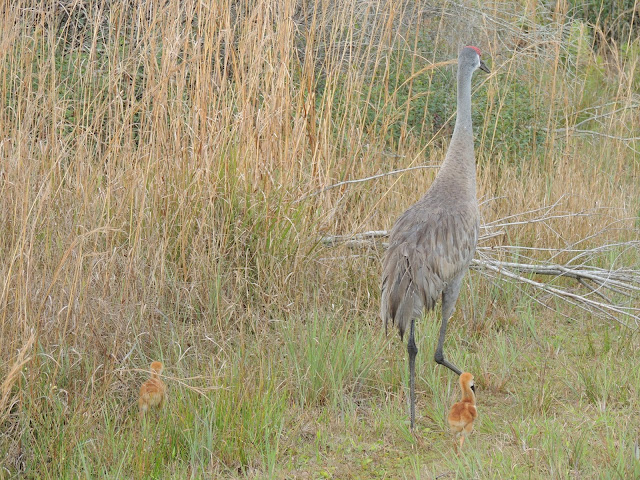
There is a sand hill crane in the middle of the photo trying to lead me away from his mate and two chicks. 
 
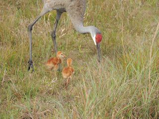
 Here is the mother sand hill crane and two newly hatched chicks.  The chicks were covered with a brownish orange fuzz.

Here is a series of photos of the mother sand hill crane and two chicks.  The mother was still catching bugs and feeding them to the chicks.


Here are a couple of photos of one of the chicks who did not want to follow his mother. 


 It is hard to spot but one of the chicks is near the middle of the photo in the grass.  They blend in well.


 This is an unnamed stream flowing north into the Little Manatee River.  The view is looking north towards the river.


 Here is a view looking upstream of the unnamed stream.  I suspect the sand deposits are laid down during floods.  The river level probably backs up into this stream causing the water velocity to drop and letting the sand settle out.


 This is the gate on the east side of Leonard Lee Rd where the trail starts.

 Here are a couple views near the east end of the trail which is a two track.


 After about an hour hiking the sun gave way to clouds and the weather slowly became threatening as a front moved in.  Could hear thunder in the distance and it slowly worked it's way closer.  About half way back to Grange Hall Road light rain started and steadily got heavier and lightening got closer.  The temperature dropped a few degrees also.  Had to put my poncho on to keep the camera and phone dry. 

 Overall it was a nice hike.  The highlight was seeing the sand hill crane chicks and being able to photograph them.


Saturday, March 12, 2016

Little Manatee River Upper Tract County Rd 579 to Gulley Creek, 2-21-16

The Little Manatee River Upper Tract extends for several miles along the Little Manatee River.  Parcels and agricultural land were purchased jointly by Hillsborough County and the Southwest Florida Water Management District (SWFWMD) 20 to 30 years ago from private land owners.  Hillsborough County manages the property. 

The map in the link below shows the area and property boundaries.
https://www.swfwmd.state.fl.us/recreation/maps/littlemanatee-upper.pdf

 Below is the start of the trail. 

The trail is a two track as shown on the USGS map but there is no sign of a trail once you enter the pasture.

Below is a newly built bridge over an un-named stream near the beginning.

From the bridge the two track trail was soggy with some areas of water that had to be waded through.


There was a pasture covered in palmettos to the south of the two track trail.


Here is where I entered the pasture. 


There were several head of cows, calves, a bull or two and a donkey.  They mainly stared at me as I made a wide arc around them. 

I use the Gaia app on an Iphone 6s plus.  I traveled through the pasture where the two track was shown on the USGS map on the app although all signs of it were gone.

In the pasture I spotted two burrowing owls.

They would fly as I slowly approached to get a  better shot.  It took quite awhile to get these photos.


At the east end of the pasture there was a fence that had to be climbed over.

East of the pasture but before entering the wooded area along Gully Creek were several tortoise holes and many tracks.  They do not show up in the photo below.  It appears someone in the past had marked the holes with 1/2" pvc pipe stakes which for the most part had fallen over.

Going down into the Gully Creek escarpment is a varied forest with palmettos, pines, oaks, and cabbage palms.

A soft rock is exposed along the edge of the escarpment in places.  I suspect it could be phosphate rock but will have to research that more.

Here is point that appears to have been used to ford Gulley Creek in the past.  It is on the path of the two track shown on the USGS map.

Another photo of Gully Creek looking in the direction of the Little Manatee River.

I did not cross Gully Creek but turned around here and headed back to the trail head.  Made another arc around the cattle and donkey in the pasture.

This is a nasty looking weed that was growing in the pasture.  It has thorns growing out of the leaves.  I am wondering if it is an invasive plant.

This bird was spotted along the two track trail on the way back to the trail head.  I have not identified it yet.

This was an interesting hike with a few challenges, mainly water, mud and high grass. 

The highlight was the photos I was able to get of the burrowing owls.